THE MAIN TRAIL

Main meny

VOKSEN

From the intersection of Sørkedalsveien and Ankerveien proceed 500 metres west down along the boundary of the golf course until the poorly paved road ends at a T-intersection. On the far side of the intersection a gravel footpath continues down a steep bank to the edge of the river and turns south.

The trail stays close to the river as it runs over rapids and divides around several mid-stream banks. A second path descends from the steep bank after about 400 m and, 150 m further down the track, the river swirls between two rock outcrops. Here, below the grass bank lie the ruins of Voksen mill. Local corn was milled here until the 1930's, using water stored in a dam built across the river between the rock outcrops. The mill itself was demolished in the 1960's because it had become a safety hazard. A few metres downstream a path runs up the bank to the miller's cottage with its distinctive porch. The trail then winds up and over a series of small rises until it reaches Griniveien where it divides. Those who must return can cross the river by the road bridge and pick up the footpath on the far bank. (The footpath leads back to Fossum and Hammer Bridge, 1 km upstream.)

GRINIVEIEN TO ULLERN MILL

The trail passes under the new bridge, past the foundations of the old road bridge which was replaced in the 1970's and directly on to an asphalt road. A few metres on is a low bridge with a barricade. It is built on the supports of a dam which supplied water to a brickworks established on the west side of the stream in 1790. Across the poundage stands a red house which provided accommodation for workers until the brick works closed in 1902. This is our second opportunity to cross Lysakerelva, either to continue downstream along the west bank on Ruud's track (quite a challenge) or to return via Fossum and Hammer Bridge.

Rail Bridge and old dam at Grini


A footpath follows the water's edge under the high rail bridge along to the Grini mill dam. In summer, the west-facing grass bank is a warm retreat for those bathing in the dam. A quern operated below the natural falls during the Middle Ages and is mentioned in tax records for 1686. From 1820 there exist the plans of a stamping mill on the site. It probably produced homespun felt for trousers and jackets. A commercial flour mill was built in 1867 using bricks from the neighbouring brickworks. The building has been considerably enlarged since it ceased operating as a flour mill in 1904, but the older section is clearly visible from the Oslo side of the dam. In 1915, it became a power station supplying about 100 local subscribers until the City of Oslo expropriated the headwaters of the river for the City's water supply in 1937. Bogstad Water acted as the reservoir and regulating basin. Now the mill houses several handwork firms and an architect's office.

"A whole town has grown up at Røa and south along the river all the way to Lysaker", wrote the leading geographer Werner Werenskiold in "Vårt Norge" in 1940. Since private properties extend down to the river bank below the dam, take the path up beside the houses and turn right into the street (Harald Løvenskiolds vei) keeping to the right at two intersections. These streets were laid out in the 1930's when the light rail to Røa was planned. The semi-rural lifestyle attracted rapid development but without an adequate sewerage system. Within ten years the river that had provided drinking water and idyllic fishing and swimming for centuries had become a stinking sewer in which neither fish nor children swam.

After a 300 metre survey of the architecture of the 1930's, with its curious mixture of styles from the traditional log cabin to the block-shaped "funkis" (functionalist) dwellings, the road swings to the left and the trail takes off to the right down a steep hill below a row of yellow apartments. At the bottom of the hill one finds oneself in the middle of a wide grassy gully that opens out towards the river. During the winter months this is a popular toboggan hill and a ski jump is built up for junior competitions. Across the gully the trail follows the river on a built-up path. A side trail bends back down hill to a bridge that leads to the west bank track. The original bridge, built in 1979, was destroyed by floods in October 1987 and replaced in 1994.

For a description of the west-bank path see Ruud's Track.


Sketch of Holte saw mill

Holte Saw Mill

The flatness and quality of the path result from its origins as the line for a collector main which was built in the 1970's to prevent storm water and sewerage from reaching the river. One hundred metres along the path, down by the river, stand four 5-metre high, masonry columns joined by fragments of stone wall. This is the site of Holte saw mill. Four sawyers worked here in 1865; the master lived in a house that stood beside the sporting fields above the steep banks a little further downstream. Access to the mill from the house was via a gully behind the mill that was filled in to create a parking area for the sports club. Unfortunately, the original drainage in the area has been disturbed by the collector main. In 2006 this led to a collapse of the supporting wall during the spring thaw. One young lad was badly hurt and the council finally repaired the wall.

Over the next five hundred metres, the river descends over 30 metres over three major falls. Each is the result of an intrusion of Permian basalt lying at an angle across the valley, resisting erosion and constricting the stream before it cascades deeper into the gorge. The best impression is gained at the second fall which can be viewed through a high, wire fence where the path rounds the corner of the embankment for sports field. On the west side of the stream the wall of grey stone which leads up the bank on the far side of the falls is an exposed basalt dike some 2 metres thick.

RØA MILL

As the river drops away, the trail follows the contour of the valley, past the first two falls but leaves the gorge before reaching the 17 m high water fall "Røafossen". Those intrepid enough to clamber over wet rocks beside the waterfall to view the sparse remains of what must have been one of the valleys most spectacular structures can take the old road at the  sign "Røa Mølle", down to the right past the foundations of "Bakken", the miller's house.

Built late last century, Røa mill rose seven storeys from river level below the falls to the level ground above the valley. Three querns drew power from the river which was dammed by a modest embankment at the top of falls, part of which still stands. From the dam spillway the fall measured 21 metres. The conglomeration of buildings was destroyed by fire around 1890.

An impression of Røa flour mill as it would be seen from the look-out on the west bankImpression Røa flour mill
Plan of the remains of Røa flour mill


Map legend


Roads to Røa Mill and Holte Saw Mill

Access to the mill could be had at four levels: from the dam wall, via the old road, via an upper road and across the fields to a loading bay at the top storey. The two middle roads are still quite clearly cut into the slope; the lower road and mill race are gone and the upper road is now on private land.

The return to the trail means a return to suburbia. The trail follows a right-of-way between houses to a street 'Elvefaret' which also dates from the 1930's subdivision. It turns right and follows the street for 200 metres. A detour to the left, however, uncovers a trace of the area's agricultural heritage. On leaving the river bank, the path has crossed the site of a tenant farm, "Nether Luggerud". The farm house is incorporated into the house now known as no. 22 Fådveien; its driveway and the driveway belonging to no.15 originally formed the continuation of Fådveien which was the road down to Røa mill from Vækerøveien. This road left Vækerøveien at what is now the bus stop at the intersection with Kristian Auberts veien. It ran directly down through apple orchards towards the present corner of Fådveien and Ove Kristiansens vei. Prior to the subdivision into housing blocks, this corner was negotiated in the wide turn required by the drays bringing corn to the mill. Behind the farmhouse, the old road is now buried under the football field. It reappears as the side path that led down to "Røa Mølle".

Returning to the Main Trail along Elvefaret, the houses date from the 1950's and 60's and vary in architecture and their use of the allotments. Post-war austerity, a 1960's version of "funkis" and traditional timber architecture are represented. The earlier buildings have been extended more or less appealingly. Number 15 was the manse for the minister of Røa Church, a irrascible fellow who had his allotment extended so that he could prevent anyone from walking past his study window as he prepared his sermons. The flat lawn between house numbers 17 and 19 was the loading bay for Røa Mill. The last house on the low (river) side is perched above the gorge with a high retaining wall supporting its garden terrace. It was built during World War II. Its Baverian sympathies are consistent with a building permit granted over public land for a house that was confiscated at the end of hostiliites. Fifty metres beyond here, a sign to Lilleaker indicates where the Main Trail leaves the asphalt and moves back towards the river's edge. Twenty-five years ago one entered a forest here but a controversial housing scheme claimed this last vestige in 1976. An alternative route through the scheme takes one away from the river, avoiding a 40 metre drop in height and providing an opportunity to experience what turned out to be one of the more successful large-scale housing developments in Oslo.

The earthworks to build the scheme have considerably altered the terrain right down to and even below the riverside path. Several deep gullies have been partially filled so the trail winds gently downhill past the white blocks with their dark timber trim. As the last block is passed, the trail swings right into a steep descent. At this point, an alternative, narrower track can be followed along the side of the slope towards the miller's house "Roligheten" ("Calm")

Plan of the ruins of Ullern Mill surveyed in 1987

Retaining wallPlan of remains of Ullern mill
Lysakerelva

ULLERN MILL

At the bottom of the hill the trail levels out and the bank is cut away close to the trail. This is the site of Ullern Mill which operated until 1913. No sign alerts the walker to its existence. The retaining wall is unsecured so one must watch one's step. In fact the wall has begun to bulge out so a collapse like that at Holte saw mill is nigh! The best view is from the south end of the site. The width of the mill race shows the water wheel to have been four feet wide. The line of the mill race can traced 80 meter back to the site of the mill dam. The dam provided a popular bathing pool prior to the pollution of the 1940's, long after the mill itself had been demolished. The wooden stone-filled coffer dam structure was demolished when it became unsafe.

ROADS TO ULLERN MILL

Ullern Mill was a commercial mill which ground corn purchased on the open market. The grain arrived by dray from the docks in Christiania and at Vækerø. The old mill road (which is shown on the topographic (ski trail) maps of Nordmarka from the 1960's) has to a large extent been retained in the present street pattern. Today, the first part is signposted by the OOT as the walking trail to 'Lilleaker'. It leaves the river bank a few metres from the Mill and crosses the river flats to the base of Lysejordet which during the ski season used to be lit up as a slalom slope and during summer is swathed in grassland flowers. At a T-intersection the old road can be followed to the right up a long slope, through one of the district's finest stands of deciduous trees with some pine and spruce to emerge in Kvernfaret. This habitat supports a squirrel population that survives despite the predations of domestic cats, and a badger set. Among the smaller plants here one finds hop ["Humle", Humulus lupulus] growing wild.

At the top of the hill the OOT signpost directs the walker to the right, down Kvernfaret towards Lilleaker. However there is a path being laid parallel to Kvernfaret in th ewood to the right. In this same wood one may find the holes dug by the archeologists who found signs of stone-age occupation (A). In the area there are also Iron Age grave sites (B) and the find of iron money bars now held in the History Museum.

One hundred years ago the flour and grain carts swung left into what has become Kvernfaret, then right up the rise and across a flat stretch before turning left in a wide bend into the street that is now called Lysehagan. The turn in fact took in the front lawn of Lysehagen 16. A hundred metres on, the road took a wide right-hand turn across the allotments of Lysehagan 8 and 10 to the line of Kvernveien, before it joined Vækerøveien at the intersection with Bjørnslettveien. The cutting in Kvernfaret and its wide intersection with Lysehagen are remnants of the original road.

A second road came from Vækerøveien down the middle of the Lysejordet slalom slope. It can be made out half way up the gully and again just above the road from the mill up to "Roligheten", the miller's residence. It is uncertain whether this road served the Mill when it was in operation or just the residence at a later date.

By following the route of the old mill road along Kvernfaret and Kvernveien, the walker comes to a point 200 metres up Vækerøveien from Bjørnsletta station on the Kolsås line. From here one can either take the no.3 train or the no.32 bus to the city or the bus back to Bogstad Camping.

The old road to Ullern mill showing how today's streets follow the old roads

Maps' legendMap Legend

Back to Røa mill

Just above old Bjørnsletta station but on the opposite side of Vækerøveien, Sportsveien, a residential street now closed off to traffic, leads off the main road through a low cutting and gently wends its way down to Ullern Idrettsforening's sportsgrounds. Following it is to follow the old road to Bjørnlia, a tenant farm that stood at what is now the corner of Sportsveien and Myntfunnveien in the late 1700's. By the 1880's it had disappeared from maps.


THE IRON-AGE FIND (Myntfunnet)

In 1947, members of the sports club were arranging a summer dance and decided to build a dance floor on the slope to the west of the sports field. As they cleared the ground they uncovered a cache of iron bars, a form of coinage used in iron-age Norway. Subsequent archeological examination revealed the remains of a smithy by the stream that flowed into the swamp here before it was filled for the sports ground.


Newspaper map of the find.

Iron-Age find from 1947


WILSE'S TRAIL

The main track crosses the river below the site of Ullern Mill over a bridge that was built in 1977 and almost carried away in the floods of 1987. The backwater below the bridge was one of the washing pools for Ullern Manor (An alternative track for the energetic walker leads past the backwater on the Oslo side; climbs up to the mill road, then winds through the birch and conifers above the river gorge). The west-bank track upstream to Grini starts a few metres from the bridge (see Ruud's Track).

The trail downstream was prepared between 1935 and 1940 by volunteers from Voll in order to link Bærumsveien to Ullern Dam. The volunteers were led by A.B Wilse, a photographer whose work represents the best of Norwegian landscape photography from the 1890s to the 1940s. Ullern Dam lay just 100 metres upstream of the present footbridge.

The track from the Dam follows the water's edge, and then climbs over the rock outcrop beside the bridge. Downstream the path follows river closely, over a series of rises (including one with wooden steps) that mark basalt dikes, past Sand Bottom, a popular bathing spot at the base of a track down from Vollterrassen, past a deeper pool where the basalt dikes provide good sunbathing during summer afternoons, and on to the river flats. For several centuries until the flour mill dam above Jar falls was demolished, this area was under water, a condition clearly shown on early maps. Wilse's team laid out a park here but the area is thick with mosquitoes and an undergrowth has regenerated. In 1999 the City of Bærum has seen to it that the narrowest and steepest parts of the trail all the way along its side of the river have been provided with hand rails but it is definitely not a path for a pram! The main trail climbs away from the river up to Bærumsveien. A short detour out along the bank brings one in sight of the tunnel carrying the river through the massive filling undertaken in the 1920's to bring Jar trikken (the No. 13 blue tram) over the river. The filling was widened during the war to carry Bærumsveien. The road was widened again in 1995 this time with a bridge, to provide a bicycle and footpath . In 2010, as part of the renovation of the rail line, a culvert was placed in the filling to allow a pedestrian passage under the tracks. Fådpassasjen as it called greatly simplifies the trip down river


BELOW BÆRUMSVEIEN

Below the road and rail crossing, the river changes its historical character. The river crossing again provides alternatives. Turning east along Bærumsveien back to the Oslo side brings one to the trail back to Ullern Mill or the Lysejordet Estate or down to Fådpassasjen to join the rough east-bank track or the main trail downstream on the Bærum side.

One can follow several trails for the first 100 meters. One of these takes us past a guide map erected by Lysaker Rotary (translation) before heading down to the river's edge.

Note immediately the change in vegetation; the sparseness and lack of variety that characterises the river bank above Bærumsveien has given way to a luxuriance with many more species. The huge filling intercepts the cold air that sinks down the valley from Bogstad Water creating a sheltered environment in which a wider variety of deciduous species thrive down by the river.

The path runs next to the stream until it reaches the first rapids where it rises behind the ruins of Jar mill. The Rotary sign shows a sketch of the mill that stood here but records of its operation stop in 1846.

The saw mills at Jar.

A further 100 m brings us to Jarfossen, the broadest and most approachable of the large falls on the river. Below the falls lay the earliest Jar saw mill of which the only remains are some logs embedded in the river bank. In 1787 this mill was replaced by a technically advanced timber mill, which for 90 years was the river Fåd's major mill; receiving logs floated from Bogstad and turning out up to 10 000 planks a year. It operated at variable capacity until 1888 when Fossum took over all timber from the forests of the Nordmarka estate.To drive this mill the falls were effectively moved 200 meters downstream by building a dam This was high enough to create a water magazine that extended all the way back to the falls impounding about 60 000 cubic meters of water. Remains of the dam are signposted on the Bærum side of the river

The pool below Jarfossen is undoubtedly the best bathing on the river. Sloping banks that catch the western sun run gently into the shallow stream so that one can get right under the "fossing" water. There are however logs and branches in the water that can be dangerous "snags".


Translation of the Rotary Map

Lysakerelva from Jar to Granfoss
- Natural and cultural history

Lysakerelva is part of the Sørkedal catchment which stretches from its sources in Heggeli and Langli Waters to its estuary into Lysaker Fiord. The stream flows 34 km and falls 450 m. The name derives from the farm which in old Norse was Ljósaker - 'the light cornfield'. Until the 1880's the name of the river separating the Hundreds of Aker and Bærum was known as the Fód or 'border'. Lysakerelva is perhaps the most important for the development of Bærum's economy. From the Middle Ages until today the river valley has been industrialised. Water rights along the river were valuable since they gave the farms along the banks power to drive mills for grain and timber.

Special minerals

The upper reaches of the catchment consist of volcanic minerals from the Permian. As a result of the especially complex geological conditions, a number of minerals have been named after localities in the catchment: sørkedalite, kjelsåsite, sørkedal porphory, akerite porphory. A small area of cambro-silurian sedimentary rocks can be found by Svartor. The valley itsef lay below the sea level in the post-glacial period and is covered by marine deposits The rich vegetation along the gives an impression of untouched wilderness close to residential areas. A walk along the river is a unique experience given the location.

Mixed forest and rich flora

Both sides of the river are covered by luxuriant vegetation with several rare species. There are substantial stands of deciduous forest including ask and bird or chokecherry. The fallen and rotting timber is a result of the long period without logging. Many plants and animals which thrive in old forest have colonised the habitat which is becoming rare in today's Norway.

Fauna

The vegetation along the river in addition to its esthetic qualities and value as a habitat modifies the climate by limiting the chilling effect of the stream. Mammals observed along the river include elk, roe deer, hare, squirrel, fox, badger, weasel , mink and marten as well as rodents and hedgehog.

Birds

Among the rarer birds nesting along the river are the dipper and. sandsnipe. Altogether 102 species have been registered

Fish

Eight species of fish including salmon and sea trout are caught Back


RUUD'S TRACK

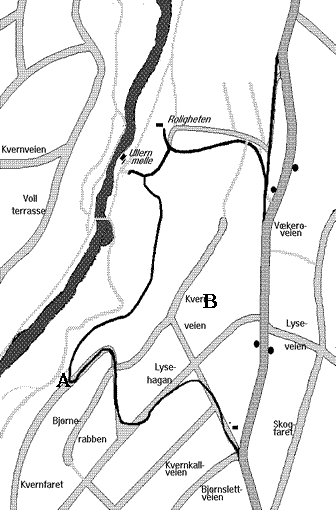
On the west bank, just north of the footbridge below Ullern Mill, the path forks with Wilse's original track leading straight ahead and a new track climbing up to the left.

The new track was cut in the late 1970's by a team from Bærum Municipal Council led by former ski-jumping champion Birger Ruud.

The track rises to a height of 10-15 metres above river level and passes Ullern Mill which can be seen on the opposite bank. An extension of Wilse's trail rejoins the track as it veers left and climbs again to a level some 25-30 metres above the river. This siting was chosen to overcome the extreme steepness with the philosophy that there should be as little disturbance as possible. Only occasional glimpses of the stream are obtained; in places, the path runs along the back fences belonging to houses in Vollterrasse and Ruglandsveien. The views are nonetheless among the most spectacular along the valley.

Ruud's Track becomes slippery and almost impassable after rain. A layer of clay covers most of the area and only rudimentary paving has been attempted. The steepest slopes have wooden staircases but these too become greasy in damp weather.

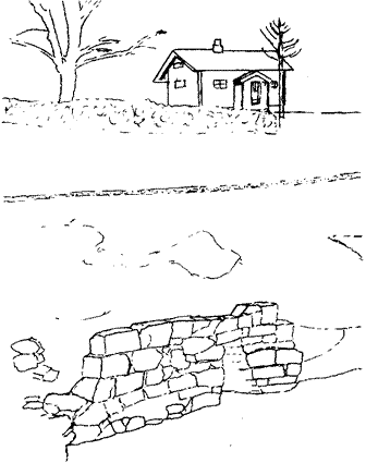
The ruins all lie on the Oslo bank but excellent views of them are available from Bærum's side. Ullern Mill can be viewed either from water level along Wilse's Track or from the top of the first rise along Ruud's Track by taking a couple of steps off the path to the top of the rock outcrop. Five hundred metres further along, as a marvellous view of Røa Falls opens up, an unmarked pad leads down to the top of the gorge. This point lies directly across the 
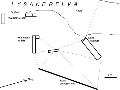
river from the site of the Røa Mill which was built up from river level to the top of the gorge. The lowest stone supports, the end of the mill race and part of the dam wall are visible today from across the river.

Fifty metres further along Ruud's Track, around the pond below the Falls, a second path leads down towards the gorge. From this point directly above the cascade, the valley widens enough to reveal a view of Holmenkoll Ski Jump through the tops of the trees.

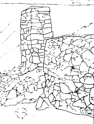
A further two hundred metres and a long staircase brings us opposite Holtet Saw Mill. Autumn storms in 1994 brought down trees here and opened up a glimpse of the ruins.

From here, the path goes down a slope and through a patch of low-lying ground to the foot bridge at Mehlumøra. At this point a wide track leads up what was once a slalom slope to Snaret, a residential cul-de-sac leading off Ruglandsveien. There are several other paths from the local streets to 
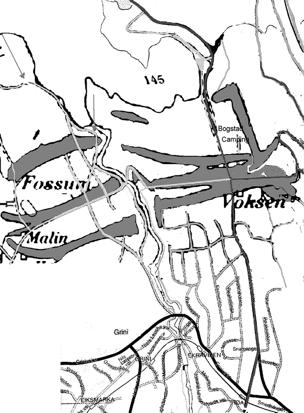
Ruud'sTrack so Bærum folk have ready access to the river.

The west bank track from here to Grini has existed since long before Ruud's track was broken in the 1970's. It continues through a stretch of pine and 
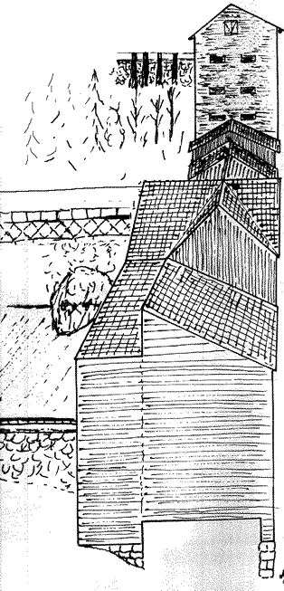
spruce into the open fields of a tenant farm which belonged to Grini. Grini Mill comes into view and the track comes down to an asphalt road. Past the Mill (which houses an architects' office, a furniture maker and an artist's studio with occasional exhibitions) and beyond the rail bridge lies Verket, the workers' dwelling for the Brickworks, the site of which is now occupied by a tennis court. Note the slate roof, the wide eaves, and the long vertical panels which indicate how high the ceilings are. Much higher than today's Norwegian residential standard of 2 m 40 (8 feet)!

FOSSUMVEIEN

Below Verket the road leads to an asphalt bicycle track that passes under the new Griniveien Bridge and up to Fossumveien. For the next half kilometer our path follows this road, with just one stop. A low grassy mound provides access to the site of the Voksen Mill Dam and a view across the river to the Mill ruins and the miller's cottage

A further hundred metres up the road, a side road leads down to playing fields on flat land beside the river. This was a back water of the river filled with scrap from a saw mill which operated for nearly one hundred years. Skirting the filling along the river bank we come to the site of Fossum Mill. Before the saw mill this was the site of an iron works with a water-driven battery. Walk to the left of the old mill warehouse and to the right of the newer offices to reach Ankerveien.

This is the heart of an industrial complex from the late 1700's that evolved from an iron mill into a major saw mill in the 1860's and was the forerunner of the major timber mill (one of Norway's largest) which occupies the south west side of Bogstad Water. There was a blast furnace directly across the river and Bogstad saw mill further upstream along opposite bank. The road and the bridge over the falls were major constructions of the 1790's built to link a series of iron works using ore mined near Sognsvann to the east and coke produced from timber from the vast forests to the north.

Ankerveien which crosses the river here continues to the east through the older part of Fossum village with its red brick school and timber houses. Between here and the filling," new" Fossum has taken over the land previously occupied by stacks of seasoning timber. Cross the Hammer Bridge which runs directly above the 7 metre high, Fossum falls that powered the saw mill. For one hundred and fifty years the bridge allowed the cartage first of iron then of timber by the local tenant farmers. In the last fifty years, the amount of foot traffic has increased as its historic value and engineering limitations have become apparent and the numbers of people living in the area have multiplied. Before climbing the hill on the east bank, look down into the old quarry on the right. Tucked under the embankment beside the road, the arched top of the blast furnace from 1786 can be seen above the rubble. It operated until 1858. Continue up the road as it swings right on to a straight, almost level section with houses on the right and the golf course on the left. At the corner of the golf course we complete our circuit along the banks of Lysakerelva and can follow Ankerveien back to Sørkedalsveien and Bogstad Camping.

A side trail takes in the start of Lysakerelva and the dam which regulates Bogstad Water. From the west side of Hammer Bridge take the old road which follows the river upstream under a high bank held by stone walls above which stand the houses built for the mill managers. On reaching a newer road and footpath at a T-intersection, pause and look at a landscape that evokes the past in two quite separate ways.

The oldest houses ahead were built for workers from the iron works. On the open land in front of us can be found the remains of numerous "miler", the kilns built up by covering stacks of wood (usually birch) with clay to make charcoal to supply the blast furnace. These operated until coal made Norwegian, charcoal-fired, iron production uneconomic in the early 1800's.

This is also a good spot to feel the power of the ice ages which released this area from its grip just 9000 years ago. The high bank beside the road behind us and the low rise extending to the west in front of us have their counterparts on the golf course on the opposite bank. They are part of the three large moraines (see the map) which extend thirty kilometres to the east and to the west at this height above sea level. Remember that this area was submerged to a depth of 70 metres during the coldest period. Vast quantities of clay and gravel were carried from the north by the ice and settled to the sea floor. As the weight of the ice decreased and the land rose, the edge of the ice cap advanced and retreated several times fashioning the clay deposits into ridges. This clay provides excellent arable land which was cultivated right down to Oslo Fjord before the suburbs invaded. As a source of grain, the area was vital in supporting of the city of Oslo.

OSDAMMEN

Turn right and follow the road parallel to the river until it bends to the left. A small shed has been built here recently by the water authority because "Osdammen" behind regulates the river flow. The dam wall with its sluice and gates could once be crossed to the site of Bogstad Saw Mill with its loading dock upstream and the mill itself just below the Dam. The Mill was established in 1868 to exploit the fall rights previously held by the Bogstad Estate. The wooden piles out in the lake were to guide the logs during floating. Today, the landowner has fenced off the dam. A sore loss to river enthusiasts.

The "Aker" moraines that dam up Bogstad Water

We stand on the dam wall in mid-stream to contemplate the waters which flow down the river. No stream of significance supplies the river below this point; to the east, its catchment extends barely a kilometer to the top of Ullernåsen, and to the west, it is just a few hundred metres to the watershed with the catchment that drains into Sandvikselva 10 km away. The overwhelming part of the flow comes from Sørkedalselva, with its ultimate sources 20 kilometres to the north in the Heggeli and Langli valleys, and from Åborbekken which both flow into Bogstad Water.

As we stand and watch the stream begin its 7 km (4 1/2 mile)journey to Lysaker Fjord we may contemplate the status of this drop "of the nectar Nature serves" about which Christian Braunmann Tullin wrote. Geographically, the river Lysaker comes to us without its sources being apparent, with the record of human endeavour along its banks only partially revealed, and the details of its geological history buried deep. The incompleteness of this guide will be corrected in time, as others who love Lysakerelva make public the details of their own researches and observations.

Last up-dated: 2012-03-25 23:22 ; webansvarlig: webmaster@lvv.no


Lebron 11 sport blue 3s retro jordans louis vuitton outlet louis vuitton outlet sac louis vuitton coach outlet online louis vuitton outlet michael kors outlet kate spade outlet cheap jordans sport blue 3s sport blue 3s louis vuitton outlet louis vuitton outlet michael kors outlet legend blue 11s louis vuitton outlet jordan 6 sport blue michael kors outlet louis vuitton outlet kate spade outlet louis vuitton outlet michael kors outlet sport blue 3s michael kors outlet louis vuitton outlet louis vuitton outlet jordans for women louis vuitton outlet Louis Vuitton Outlet jordan 6 history of Jordan lululemon yoga pants louis vuitton outlet cheap air jordans louis vuitton outlet michael kors outlet sport blue 3s jordan 3 sport blue history of jordan 6s